


Aviation
ideaForge Launches Q6V2 GEO UAV, Redefining the Future of Geospatial Intelligence
ideaForge Technology Limited, a leader in drone innovation, has unveiled its most versatile mapping UAV to date, the Q6V2 GEO, at the company’s inaugural customer event themed “Advancing Possibilities in Geospatial Intelligence.” The launch marks a significant milestone in ideaForge’s mission to provide industries, researchers, and government agencies with next-generation aerial mapping and intelligence solutions.
Built for Any Terrain, Any Mission
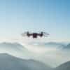
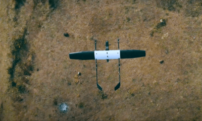
Designed to “map anything, anywhere,” the ideaForge Q6V2 GEO is engineered for all-terrain performance, from Himalayan glaciers to dense forests, bustling urban corridors, and industrial sites. Despite its powerful capabilities, the UAV maintains a take-off weight under 7 kg while offering over 50 minutes of flight time with a LiDAR payload.
Precision is central to the design: the ideaForge drone integrates an advanced IMU, PPK-enabled geotagging, and seamless CORS connectivity for survey-grade accuracy. What sets the ideaForge Q6V2 GEO apart is its modular payload capacity, supporting five interchangeable options, including:
-
SHODHAM M61, a newly launched 61 MP AI-enabled camera,
-
LiDAR sensors,
-
Oblique imaging,
-
Hyperspectral sensing, and
-
Thermal detection.
This flexibility allows the platform to adapt seamlessly across diverse use cases.
Introducing the Q6 V2 GEO – the mapping multi-tasker built for extremes.
From Himalayan peaks to crowded city grids, it adapts seamlessly to every mission. With multi-payload versatility, 55 minutes of endurance, and backpackable portability, it delivers survey-grade accuracy… pic.twitter.com/XFYhNNZF0k
— ideaForge Technology Limited (@ideaforge_tech) August 20, 2025
From Archaeology to Agriculture
Paired with ideaForge’s new geospatial tech stack and its secure Flyght Cloud platform, the Q6V2 GEO transforms raw UAV data into decision-ready insights. Its applications span across industries and research fields:
-
Disaster Response: rapid terrain assessment in remote and high-altitude areas.
-
Urban Planning: creating 3D city models and conducting infrastructure audits.
-
Mining: automating compliance reports and calculating extraction volumes.
-
Utilities: tower inspections and vegetation risk management.
-
Agriculture: early crop stress detection and productivity enhancement.
-
Forestry & Water Resources: biomass analysis and habitat monitoring.
-
Archaeology: high-resolution mapping of ancient petroglyphs for digital preservation.
Notably, the UAV has already been deployed in Himalayan glacier mapping for avalanche prevention and municipal governance projects in Varanasi.
Speaking on the launch, Ankit Mehta, CEO of ideaForge, said: “The Q6V2 GEO, along with our geospatial tech stack, is a leap forward in geospatial intelligence. From mapping glaciers to surveying urban corridors, this platform advances possibilities and empowers decision makers to act with precision in the most demanding terrains and climates.”

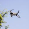
ideaForge Drone – Q6V2 GEO
Shaping the Future of UAVs
With its advanced payload integration, AI-powered imaging, and secure cloud capabilities, the Q6V2 GEO positions ideaForge as a trailblazer in next-gen geospatial intelligence. By bridging aerial data with actionable insights, the UAV is set to become a cornerstone technology for industries navigating increasingly complex challenges.
As industries seek smarter, faster, and more sustainable solutions, ideaForge’s Q6V2 GEO proves that the future of mapping is not only airborne—it’s intelligent.


Pingback: Matrix Geo + DRIIV: Partnership To Redefine India’s S&T Missions